Why a Border Can Be More Than a Line on a Map
Why a border can be more than a line on a map: learn to read its legal, practical and cultural roles, and see why one boundary rarely defines a whole place.
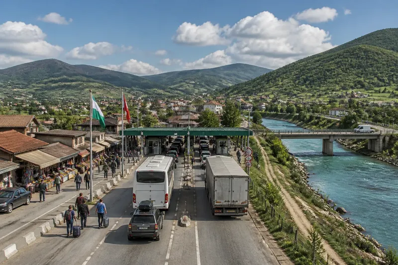
Why a border can be more than a line on a map becomes clear when a traveller reaches a crossing and sees paperwork, queues and familiar faces on both sides. The border is a boundary between states, but it can also organise movement, mark authority or cut across a place that people understand as connected. To read it well, start with the question you are trying to answer.
Start with the job you need the border to explain
A map usually draws a border as a single stroke. On the ground, that stroke may correspond to several different things: a legal limit, a checkpoint, a change in local administration, or a boundary that matters to a community. These do not always coincide.
That is why a useful account does not ask only, “Where is the border?” It also asks, “Who uses it, for what purpose, and at what scale?” A country’s legal boundary might be clear on an official map, while the customs post is some distance away. A community’s everyday ties may continue across both.
Choose the lens that fits your question. If you are trying to understand authority, look at law and administration. If you are thinking about a journey or a supply route, look at crossing points and controls. If you want to understand belonging, listen for the names and connections people use for the wider place.
Look for authority when the question is who governs
For questions about sovereignty or public administration, the political border is the right starting point. It indicates which state claims authority within a territory and where its laws and institutions generally apply. National maps, official documents and government services commonly organise information around this boundary.
But a political line does not tell you everything about how authority works. A border may be internationally recognised while its precise course is disputed, or government services may be concentrated far from the edge. A line on a map is evidence of a claim or an agreed arrangement; it is not, by itself, a description of every person’s daily experience.
Say you are comparing two school systems in a border district. If the question is which ministry sets the curriculum, the state boundary is a sensible guide. If the question is which school children can reach easily, the same line may explain much less than roads, transport and local arrangements.
Follow crossing points when movement is the main concern
For travel, trade or migration, focus on the border as a system of passage. Roads, rail links, ports and official crossing points shape how people and goods move. Some stretches may be easy to cross; others may have checks, limited access or no public route at all.
A frontier is the broader zone where neighbouring jurisdictions meet. It can include settlements, farmland, transit routes and checkpoints rather than one visible barrier. The word is especially useful when the question concerns how contact happens along an edge, not only where a boundary is drawn.
Imagine a market town whose farms and customers lie on both sides of a state boundary. A map can identify which country contains each street, while a local transport map can show where people actually cross to reach the market. The first helps explain jurisdiction; the second helps explain the town’s working connections.
For a journey, consult current official travel information and check the requirements that apply to your route and documents. A nearby crossing shown on a map may not be open to every traveller or type of transport.
Listen for belonging when a boundary seems too narrow
When the question is how people describe where they live, a cultural or historical region may be more useful than a state border. Such a region can be shaped by language, family ties, landscape, religious life, shared institutions or memories of movement. Its edges may be gradual and overlapping rather than sharply marked.
This does not mean everyone within a region shares one identity, or that a cultural connection settles a political dispute. People can describe themselves through a town, a valley, a language community, a country or several of these at once. The label that fits depends on the speaker and the conversation.
Take care with broad regional names. They can help readers see connections that national maps leave out, but they can also make a diverse area sound uniform. Look for who uses the term, what area they include and whether residents use other names alongside it.
Choose the border lens that fits your question
- Who makes the rules? Start with the political boundary and the institutions responsible for law and administration.
- Where can people or goods pass? Look at crossing points, transport links and the rules governing movement.
- Why do neighbours feel connected? Consider cultural, economic and family ties that may extend across a state line.
- Why does a map disagree with local descriptions? Compare the map’s purpose with the terms and scales residents use.
- Is the boundary disputed or unclear? Separate the mapped claim, the legal position and the situation people encounter on the ground.
Use more than one lens when the question asks for more than one kind of answer. A political map and a local transport map are not competing versions of the same story; each is made to show different information. Pairing them can reveal both the limit and the connections around it.
What should you check before describing a border?
Does a border always have a physical barrier?
No. It may be marked by a fence or checkpoint, but many borders are not visible as continuous structures. A line can still have legal force even where the landscape looks unchanged.
Can a region cross an international border?
Yes. A region defined by language, trade, landscape or community ties may extend into more than one state. Its reach depends on the feature being discussed, so name that feature rather than implying a single shared identity.
What is the difference between a border and a frontier?
A border usually means the boundary separating jurisdictions. A frontier often refers to the wider area where those jurisdictions meet and interact, though usage varies by context.
Which map should I use?
Choose a map that matches your question: an administrative map for jurisdiction, a transport map for routes, or a regional map for connections. Check its legend and stated purpose, since the same place can be divided differently across maps.
Describe the line and the life around it
When writing or talking about a border, say what kind it is before treating it as an explanation. “International boundary” points to state authority; “crossing point” points to movement; “cultural region” points to a pattern of belonging. Clear wording stops one map line from carrying claims it cannot support.
The search for why a border can be more than a line on a map is really a search for scale: the answer changes with the question. For a decision about jurisdiction, use the state boundary. For a decision about travel or exchange, follow the routes and crossing rules. For a description of local identity, attend to the names and ties people themselves recognise. The most useful map is the one that shows the feature you need—and the most careful explanation says what it leaves out.